Project & Construction Timelines
When will the project start?
Construction is anticipated to begin in spring 2025. Tree clearing activities are anticipated to begin in early 2024.
How long will construction take?
Construction is expected to take up to two years, or two construction cycles, to complete.
Project Design
Will there be any roundabouts?
Roundabouts will not be associated with the South County Line Road improvements, however, there will be roundabouts added at the I-69 interchange with South County Line Road where the ramps connect.
Will we get bike lanes?
There would be no dedicated bike lanes added to South County Line Road, however, a 10-foot multi-use path would be added to the north side of South County Line Road.
Will new sidewalks be built?
Yes. A 6-foot sidewalk would be added to the south side of South County Line Road. A 10-foot, multi-use path is also planned for the north side. Pedestrian crosswalks and signals would be added at South County Line Road and Morgantown Road, Railroad Road/Peterman Avenue, and Madison Avenue/SR 135.
Will the hill at the intersection at South County Line Road and Morgantown Road be improved?
Yes. The proposed project includes a significant reduction in the hill slope to increase safety. Retaining walls will be constructed in the area to minimize the impacts to adjacent property and steep side slopes.
Will there be any future changes to the proposed project design?
The environmental (NEPA) process is still ongoing and changes to the proposed project design could occur during final design. The environmental process is anticipated to be completed in Winter 2023/2024.
Project Amenities
Why is it necessary to have both a sidewalk and a walking path?
South County Line Road is being designed to better meet the needs of modern urban life. This includes the use of features like sidewalks and multi-use trails. A sidewalk is a separated facility intended only for use by pedestrians. Since there are no bike lanes associated with the South County Line Road project, the multi-use trail allows for multi-modal access for pedestrians, bicyclists, and rollerbladers. Currently, there are a limited number of pedestrian or multi-modal facilities on South County Line Road, and both are necessary to provide increased mobility throughout the project corridor.
Water/Sewer/Drainage
Will water and sewer extensions be provided as part of this project?
Water and sewer extensions are not anticipated to be included in the project. However, the proposed project design would accommodate a location for the expansion of these services along South County Line Road in the future.
Drinking water and sanitary sewer services are provided by several utilities within the proposed project area that would be responsible for any extension of services. However, none of the utilities currently have expansion plans that include South County Line Road. If the utilities do expand along South County Line Road, programs such as the Citizens Energy Group Septic Tank Elimination Program (STEP), could help guide residents through the connection process.
If drinking water wells, groundwater supply wells, or septic systems require location due to project construction, a cost to cure payment will be made to the property owner. If suitable drinking water or wastewater services cannot be provided, additional compensation, including relocation may be warranted.
Is anything going to be done to address frequent flooding?
South County Line Road east of Morgantown Road would be raised around Pleasant Run Creek to address area flooding. Both curb and gutter and open and enclosed storm sewer systems would be used in the proposed project design. Detention basins would be used in conjunction with the storm sewer systems to detain stormwater. Additionally, the proposed bridges at Pleasant Run Creek and Buffalo Creek have been designed to accommodate a 100-year flood event and would not raise flood elevations upstream.
How has drainage and flooding been evaluated for this project?
A drainage study has been completed within the project area, including an evaluation of both the Pleasant Run Creek and Buffalo Creek bridges. The study also included an evaluation for stormwater. The project includes both open and enclosed storm sewers and stormwater detention to accommodate increased stormwater flows associated with the increased nonporous pavement. Both proposed bridges are larger than the existing bridges and are designed to accommodate 100-year flood flows without increasing flood elevations upstream of the project.
Property Acquisition
Are you going to buy my house?
Property acquisition is anticipated. However, the environmental (NEPA) process is still ongoing, and plans are preliminary and subject to change. Those residents that are most likely to be affected by relocation have been contacted by the project team.
Is there someone I can contact about property acquisition right now?
A wide variety of Information about real estate acquisition is available online from the Indiana Department of Transportation (INDOT) and the Federal Highway Administration (FHWA). Property acquisition for the South County Line Road project will be overseen by Jason McCort with HNTB. He can be reached at jmccort@hntb.com or 317-636-4682 with any immediate questions.
In addition to the current right-of-way, how much land will be acquired from properties along County Line Road?
The road will be widened equally on the north and south sides of County Line Road. The amount of right-of-way would typically vary somewhere between 60 to 90 feet on either side of the roadway. The project is still under preliminary design and property acquisition would be subject to change during land acquisition.
Utilities
If the project advances, when would utilities be moved?
Utility relocation will begin in early 2024 in conjunction with tree clearing activities.
Who is responsible for buried electrical lines?
AES and Duke Energy would be responsible for utility pole relocation as well as any decision to bury electrical lines along South County Line Road.
Traffic Concerns
Will I always be able to get out of my house/addition?
Yes. Access to homes in the project area will remain open throughout the project.
How was it determined there should be 5 lanes?
A Scoping Report was prepared and was part of the decision-making process to determine the number of lanes needed to address project purpose and need.
Project Cost & Funding
How much is the project going to cost?
The preliminary total project cost is estimated to be approximately $40 million.
Who is paying for this?
This project is being sponsored by the City of Indianapolis with funding from both the City and INDOT.
Facility Closures
Will the road ever be completely closed?
During Phase 1 of construction, there would be a road closure along South County Line Road from Morris Road to Rocky Ridge Road. This would include the Morgantown Road Intersection and the Pleasant Run Creek Bridge.
Will the bridges be closed?
The bridge over Pleasant Run Creek (near Morgantown Road) would be temporarily closed during Part 1 Phase 1 of construction, but the bridge will be built in phases to accommodate a haul route for earthwork. The bridge over Buffalo Creek would be constructed in Part 2 of the corridor over two phases. Two lanes, one in each direction, will remain active over the creek at all times.
Project Coordination
Has the City coordinated with Johnson County about this project?
As part of the design process, the project team engaged in early coordination with officials from Johnson County, Marion County, and the City of Greenwood to discuss the proposed project and mitigate as many potential impacts to residents as possible. Further coordination between the groups would continue throughout project completion.
Snow Removal & Grass Cutting
Will property owners be responsible for snow removal and grass cutting along the walking path and sidewalk?
Yes. By order of City ordinance, property owners are required to mow the adjacent grass between the sidewalk and their property as well as clear any sidewalk/path in front of their home.
Noise
When is Noise Abatement Required?
Procedures for Abatement of Highway Traffic Noise and Construction Noise (FHWA)
INDOT Traffic Noise Analysis Procedure (INDOT Noise Policy)
Noise abatement measures are considered when the predicted noise levels approach or exceed those values shown in Table 1 below or when the predicted traffic noise levels substantially exceed the existing noise levels. INDOT has defined the approach value to be within 1.0 dBA of the appropriate Noise Abatement Criteria (NAC) Category. According to the INDOT Traffic Noise Analysis Procedure (INDOT Noise Policy), an increase in noise levels for which the future noise levels exceed the existing noise by 15.0 dBA is substantial.
The South County Line Road project study area consists of residential (NAC Category B), noise-sensitive commercial (NAC Category E), institutional (NAC Category C), and non-sensitive land uses (NAC Category F). The criteria stated in Table 1 were used to determine if the proposed project would produce noise levels that approach or exceed the NAC throughout the corridor.
Table 1: Noise Abatement Criteria (NAC)
Hourly A-Weighted Sound Level-Decibels (dBA)
| Activity Category | Activity Criteria Leq(1h) | Evaluation Location | Activity Description |
| A | 57 | Exterior | Lands on which serenity and quiet are of extraordinary significance and serve an important public need and where the preservation of those qualities is essential if the area is to continue to serve its intended purpose. |
| B | 67 | Exterior | Residential |
| C | 67 | Exterior | Active sport areas, amphitheaters, auditoriums, campgrounds, cemeteries, daycare centers, hospitals, libraries, medical facilities, parks, picnic areas, places of worship, playgrounds, public meeting rooms, public or nonprofit institutional structures, radio studios, recording studios, recreation areas, Section 4(f) sites, schools, television studios, trails, and trail crossings. |
| D | 52 | Interior | Auditoriums, daycare centers, hospitals, libraries, medical facilities, places of worship, public meeting rooms, public or nonprofit institutional structures, radio studios, recording studios, schools, and television studios. |
| E | 72 | Exterior | Hotels, motels, offices, restaurants/bars, and other developed lands, properties or activities not included in A-D or F. |
| F | N/A | N/A | Agriculture, airports, bus yards, emergency services, industrial, logging, maintenance facilities, manufacturing, mining, rail yards, retail facilities, shipyards, utilities (water resources, water treatment, electrical), and warehousing. |
| G | N/A | N/A | Undeveloped lands that are not permitted. |
Has there been an impact study on noise?
A noise analysis has been completed within the project area and the report is available on the Documents page of the website.
Existing noise level measurements were conducted on November 5, 2020, at five representative sites along the project corridor. A 20-minute measurement was taken at each location which was selected based on distribution throughout the project corridor.
The latest version of FHWA’s Traffic Noise Model was used to model existing (2020) and design year (2045) worst hourly traffic noise levels within the South County Line Road project study area. The study area included receivers located within 500 feet from the roadway. Receivers consisted of residences, a church, two noise-sensitive commercial land uses, and an assisted living facility, as well as non-sensitive commercial land uses.
Existing residential noise levels along South County Line Road ranged from 45.7 to 64.6 dBA Leq(1h). With the proposed expansion of South County Line Road, noise levels at residential receivers would range from 50.8 to 65.9 dBA Leq(1h). The change in predicted future noise levels over existing noise levels ranged from 2.2 to 6.7 dBA.
As the predicted noise levels do not exceed the NAC or substantially exceed the existing sound level, noise abatement is not proposed.
How is Noise Measured?
Noise is defined as unwanted and disruptive sound. Airborne sound occurs from the rapid fluctuation of air pressure above and below the atmospheric pressure. The ear is sensitive to this pressure variation and perceives it as sound. The intensity of these pressure variations causes the ear to detect different levels of loudness. These pressure differences are most commonly measured in decibels (dB).

There are five types of highway noise sources:
- Automobiles – all vehicles with two axles and four tires, includes passenger vehicles and light trucks, less than 10,000 pounds.
- Medium trucks – all vehicles having two axles and six tires, vehicle weight between 10,000 and 26,000 pounds.
- Heavy trucks – all vehicles having three or more axles, vehicle weight greater than 26,000 pounds.
- Buses – all vehicles designed to carry more than nine passengers.
- Motorcycles – all vehicles with two or three tires and an open-air driver/passenger compartment.
Noise levels produced by highway vehicles can be attributed to three major categories:
- Running gear and accessories (tires, drive train, fan and other auxiliary equipment)
- Engine (intake and exhaust noise, radiation from engine casing)
- Aerodynamic and body noise
Tire sound levels increase with vehicle speed but also depend upon road surface, vehicle weight, tread design and wear. Change in any of these can vary noise levels. At lower speeds, especially in trucks and buses, the dominant noise source is the engine and related accessories.
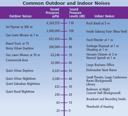
The following table shows common outdoor and indoor sources of noise for reference:
Will noise barriers or fencing be added along County Line Road?
Following the completion of a noise analysis, it was determined that noise barriers would not be required as part of this project.
What would it take for noise abatement to be part of the project?
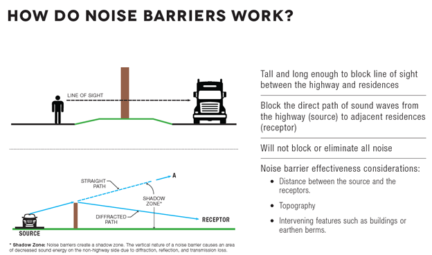
Noise barriers reduce noise by blocking the direct travel of sound waves from a source to a receptor, such as an adjacent home or business. To work properly the barrier must be high enough and long enough to block the view (line of sight) of the noise source. Because of the necessary openings or gaps required for driveway connections or street intersections, noise barriers are not effective in residential areas such as along South County Line Road and therefore would not be utilized.
Community Interest
Will there be any new traffic signals?
The traffic signal at Morgantown Road would be replaced and a new, permanent traffic signal at Railroad Road would be installed. Improvements to the traffic signals and intersection at SR 135 will also be completed as part of a separate INDOT project.
How will this intersect with I-69?
Once completed, South County Line Road would connect to I-69 with a double roundabout interchange. A single roundabout on each side of the interstate would provide access to north and southbound ramps. I-69 will pass over South County Line Road.
What will the speed limit be?
The speed limit on the redesigned South County Line Road would remain 40 mph, as is currently posted east of the Morgantown Road intersection.
How will this affect school bus routes?
School bus routes would not be impacted by this project. Coordination with area school districts was initiated early in the design process to address any project-related concerns. This coordination would continue through construction.
How will this affect fire and police access?
Fire and police access would not be restricted. Coordination with local officials, emergency response agencies, and road and planning organizations was initiated early in the design process to address any project-related concerns.
Project Team Contact Information
Who do I contact for more information?
Please contact Cassidy Hunter at HNTB for further information.
Cassidy Hunter
111 Monument Circle, Suite 1200, Indianapolis, IN 46204
(317) 636-4682
